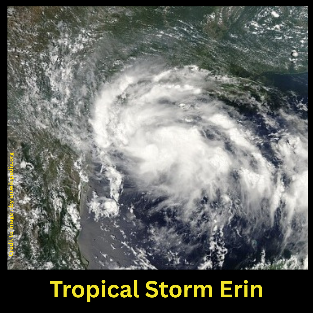
Tropical Storm Erin, the fifth named storm of the 2025 Atlantic season, is gaining strength fast. It is expected to become the first hurricane of the year by Friday 15 August 2025 and could reach Category 3 by the weekend. Currently traversing the eastern Atlantic, Erin’s projected path skirts north of the northern Leeward Islands, with indirect impacts such as heavy rain, rough seas, and rip currents expected across the Caribbean and possibly beyond. While a direct U.S. landfall seems unlikely for now, the situation remains fluid and demands vigilant monitoring.
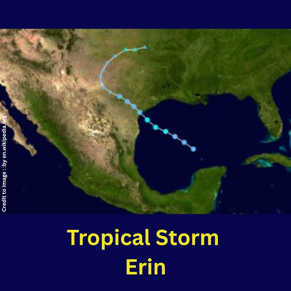
Table of Contents
- Introduction
- Formation & Current Status
- Scientific Data Table
- Timeline: Erin’s Key Dates, Times & Locations
- Areas Potentially Affected
- Summary of Projected Impacts
- Conclusion
- FAQs
- References
Scientific Data Table
| Parameter | Value |
| Date details | Erin Tropical Storm on 11 August 2025 (Yale Climate Connections) |
| Initial Location | ~300 mi west-northwest of Cabo Verde (17.4° N & 28.0° W) on 11 Aug 2025 (Yale Climate Connections) |
| Current (latest) Location | ~16.9° N, 51.9° W as of Aug 15, 00:00 UTC; moving west at ~15 mph (Weather Underground) |
| Current Wind Speed | ~70 mph sustained winds (Weather Underground) |
| Current Pressure | ~999 mb (Weather Underground) |
| Forecast Intensification | Hurricane by Friday; possible Category 3 by weekend (CBS News, The Washington Post, AP News, El País) |
Timeline: Day, Time, & Geographic Location
| Date (2025) | UTC Time | Location (Lat, Lon) | Stage / Notes |
| August 11 | ~11:00 a.m. EDT | ~17.4° N, 28.0° W | Named Tropical Storm Erin (Yale Climate Connections) |
| August 13 | around 03:00 UTC | ~16.3° N, 45° W | Strengthening; winds ~50 mph (Weather Underground) |
| August 14 | 21:00 UTC | ~16.7° N, 51.2° W | Winds ~60 mph, pressure ~998 mb (WXII, Weather Underground) |
| August 15 | 00:00 UTC | ~16.9° N, 51.9° W | Winds ~70 mph, pressure ~999 mb (Weather Underground) |
Affected Areas & Regions of Concern
- Northern Leeward Islands, Virgin Islands, Puerto Rico – tropical storm watches issued; heavy rainbands, high surf, possible squally winds expected .
- Antilles (Anguilla, Barbuda, St. Martin, Sint Maarten, Saba, St. Eustatius) – Tropical storm watches in effect.
- Caribbean Islands, Puerto Rico, Martinique – Rainfall, Possible flash flooding, Gusty winds, landslides etc.
- Bermuda, U.S. East Coast – indirect impacts likely: powerful swells and rip currents; main path likely to remain offshore, though uncertainty persists.
Summary
Tropical Storm Erin stands on the brink of becoming the 2025 Atlantic season’s first hurricane, with rapidly intensifying conditions fueled by warm waters and favorable atmospheric factors. Its current trajectory keeps it just north of key Caribbean islands, avoiding direct hits but posing secondary hazards—heavy rainfall, coastal turbulence, and flooding—to those regions. Forecast models suggest it will continue northward between Bermuda and the U.S. East Coast, posing minimal direct threat—but still warranting cautious observation given forecast uncertainties.
Conclusion
As Erin evolves, its trajectory offers a fleeting sense of relief to the Caribbean and U.S. East Coast, likely avoiding a direct hit. Yet, the indirect consequences—like dangerous waters, flooding, and coastal erosion—are real and warrant preparedness. Erin underscores the escalating nature of Atlantic hurricane seasons in a warming climate and reiterates the importance of robust early-warning systems and community readiness.
Frequently Asked Questions
- When did Erin become a named storm?
It was designated Tropical Storm Erin on August 11, 2025, around 11 a.m. EDT. - Where did Erin originate?
Erin originate from west-northwest of the Cabo Verde Islands. Near 17.4° N & 28.0° W. - How fast is Erin moving?
It’s moving westward at roughly 15–17 mph. - What are its wind speed and pressure now?
Erin hurricane wind speed and pressure are ~70 mph, with pressure around 999 mb. - When is it expected to become a hurricane?
Forecasts indicate it should become a hurricane by Friday and possibly reach Category 3 strength by weekend. - Which areas are under watch?
Northern Leeward Islands, Virgin Islands, Puerto Rico, Anguilla, Barbuda, St. Martin, Sint Maarten, Saba, and St. Eustatius. - Will the U.S. be directly impacted?
The U.S. East Coast should prepare for hazardous surf and rip current conditions, which may be directly impacted . - What are the main threats Erin poses?
These include high surf, dangerous rip currents, coastal flooding, heavy rain, and squally weather in affected regions.
Frequently Asked Questions
- Why is Erin intensifying?
Favorable conditions such as warm sea surface temperatures (up to 29 °C), low wind shear, and moist atmosphere are aiding its rapid intensification. - How typical is this timing?
Erin is the fifth named storm of the season and is on track to become the first hurricane around August 13–14—close to the climatological average. - Are there similar storms in history?
Several storms formed near Erin’s location have veered away from land; some like Florence (2018) and Irma (2017) had major impacts—but Erin’s comparatives remain speculative. - Can its path still change?
Yes—forecast models still have variability. A westward shift toward the U.S. East Coast cannot be ruled out. - What should residents do?
Those in watch areas should prepare for tropical storm conditions; others should monitor updates and heed local advisories. - Why monitor Erin in a nature/environment magazine?
Erin highlights how climate change influences storm intensity and frequency—underscoring the link between environment and extreme weather. - Where can one track real-time updates?
Consult sources like the National Hurricane Center (NHC), Weather.com, and regional meteorological services.
References
- The Cool Down
- The Weather Channel
- CBS News
- The Washington Post
- AP News
- Yale Climate Connections
- Weather Underground
PRAKRITI DARSHAN-NATURE AND ENVIRONMENT MAGAZINE
Prakriti Darshan is a leading Hindi-language magazine and digital platform dedicated to raising public awareness on vital issues related to nature, biodiversity, climate change, sustainable development, and environmental conservation. This magazine represents a unique blend of science, society, and sensitivity—offering a common platform for researchers, students, NGOs, policymakers, nature lovers, and conscious citizens alike.
With thought-provoking articles, inspiring stories, environmental research, impactful projects, and policy perspectives, Prakriti Darshan is a transformative journey toward a greener and more sustainable future.
Let us come together to protect and preserve our planet for generations to come. 🌿🌍
Join us in our mission to protect and celebrate the planet. 🌏💚
Click for more information
- Visit www.prakritidarshan.com for Free Magazine ,Free membership benefits ,offered price magazine @ Rs.1 or Rs.11 only and more ……
- 🎗️Sponsor Prakriti Darshan Magazine – Support our environment mission.
- 📚 Explore the Environment Magazine – Read our latest and past issues.
- ✍️ Read Editor’s Article or Blog – Insightful thoughts from our editorial desk.
- 🌱 Join Membership – Be part of India’s leading green community.
- 🤝 Become an NGO Impact Story Partner – Share your grassroots impact nationwide.
- 🏢 Become a Company Partner – Showcase your CSR, ESG, or sustainability work.
- 👤 Become an Individual Partner – Volunteer, write, and raise your green voice.
- 📢 Advertise with Us – Reach eco-conscious readers across India.
- Eco Trails Newsletter
- Donate for “Hari Ho Vashundhara & Har school Hariyali “ Plantation campaign Associated Partner NGO :GDSS NGO www.gdssngo.org
BALA DATT SHARMA,
MANAGING EDITOR ,
PRAKRITI DARSHAN-NATURE AND ENVIRONMENT MAGAZINE
- Drake Passage: The World’s Roughest Sea Route Between Atlantic and Pacific Oceans - August 22, 2025
- Top 10 Natural Parks in the USA: Biodiversity, Geography & Global Relevance - August 21, 2025
- Exploring the Best Natural Parks in USA: Biodiversity, Sustainable Tourism, and Role in SDGs - August 21, 2025